Data-Driven Approach Analyzes Stream Migration to Reduce Risk of Sanitary Sewer Overflows
Digital tool determines which assets are at greater risk of stream migration damage and prioritizes inspections accordingly.
At a Glance:
- Fairfax County partnered with Hazen to develop a data-driven and risk-based approach to identify and prioritize inspection for more than 9,000 sewer assets.
- Hazen developed an innovative approach to risk modeling that uses stream science principles to inform asset management practices.
- A specialized geospatial model is used to understand the risk to sewer assets located near streams and prioritize field inspection activities.
- Field inspection crews collect relevant information about the environment around the sewer crossing that are directly fed into a separate decision tree model which will be used to facilitate the inspection re-prioritization, rehabilitation, and repair recommendations where warranted.

Russ Dalton is Hazen’s Mid-Atlantic Regional Asset Management Service Lead, guiding utilities in the process of implementing digital tools for asset management and optimization.
Ryan O’Banion is Hazen’s Director of Geospatial Services, using GIS, statistics, and field assessments to inform stormwater and sanitary sewer management decisions.
Paul Le Bel is a key member of Hazen’s Stream Restoration Team, specializing in the design and construction of sanitary sewer protection measures within streams.
Related Solutions:
To reduce the risk of sanitary sewer overflows caused by exposure of and damage to sewer assets within the stream corridor, Fairfax County, Virginia partnered with Hazen to develop a data-driven, risk-based approach to the identification, prioritization, and inspection of more than 9,000 sewer assets located in proximity to streams throughout the County. Under a pilot program, Hazen developed the foundational pieces of an inspection program, including:
- Creek Crossing-specific risk framework and model
- Field inspection methodology
- Rehabilitation decision tree model
After the completion of over 250 pilot inspections, Hazen was asked to implement the approach as a County-wide, annual inspection program.
Hazen’s Project Team uses a suite of ArcGIS Online tools including Field Maps and Survey123 to develop, assign, and complete field inspections. Hazen also developed a series of operations dashboards which provide both the Hazen and County project teams with important progress information and access to inspection data and media.
Related: To help the city of Boston prepare for extreme storm events, Hazen developed the Inundation Model Viewer with ESRI. The fully dynamic interface displays predicted flooding for different events, critical facilities impacted, and is fully interactive.
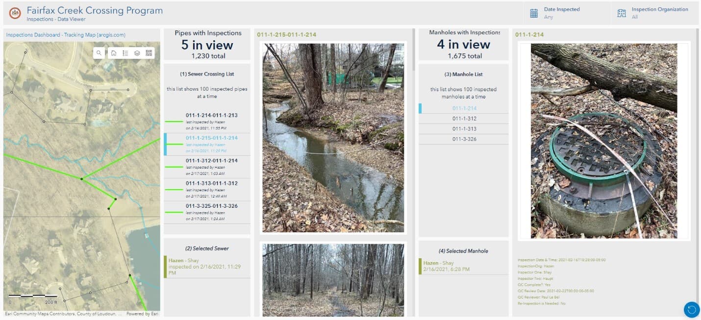
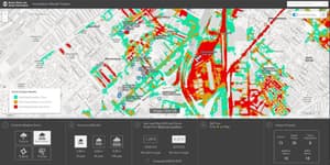
The Fairfax Creek Crossing Program’s dashboard pulls together asset data, in this case sewer crossings and manholes inspection data and photos, to allow for quick decision-making and identification of any maintenance needs.
Combating the Effects of Stream Migration
Stream migration and its destructive effects on infrastructure are a primary concern for Fairfax County, Virginia. It is a gradual process that occurs when a stream erodes one side of its bank and deposits sediment along the other side. Over time this shifts the stream’s location, making it more likely to damage infrastructure during wet weather. When floodwater moves in, aging assets are at a greater risk of breaking and causing sanitary sewer overflows that contaminate the water supply and threaten water quality.
Sanitary sewer overflows are prohibited by the EPA, and the cost of cleaning up after an overflow greatly outweighs the cost of maintaining infrastructure before it fails. To predict the likelihood and consequence of an asset’s failure, Hazen used Innovyze’s InfoAsset Planner to create a risk model specific to the stream environment. Hazen then developed a desktop spatial analysis in GIS using Python scripting to create a repeatable process, which allows the team to update the risk analysis on a periodic basis as more refined data become available.
“The endpoint is a time-based understanding of risks. The model shows us which issue is imminent, what’s coming up in the next year, and what we need to prepare for in 10 years. The ability to strategically prioritize inspections up over time is invaluable.”
~ Ryan O’Banion, Hazen's Director of Geospatial Services
Combining Layers of Data
An ArcGIS Dashboard and StoryMap pull the data together into accessible web applications. Here, a decisionmaker can see the big picture, or zero in on key factors—such as soil erosion potential, impervious area, and others—that make up the assessment.
After the view of risk is established, a field team can complete an on-site physical assessment. This allows for a rapid and accurate evaluation of both the sewer assets and the stream’s conditions, which are immediately uploaded to the cloud-based data management system and fed into the dashboard.
Continuing to Optimize Planning
With regular updates, the Fairfax County Creek Crossing Program will continue to help the County predict and prioritize inspections so that the highest risk assets are addressed first. The enhanced ability to address short and long-term issues related to stream migration will help decrease the likelihood of future overflows, and help the County maintain high infrastructure and water quality standards.