Storytelling Helps Residents Understand Stream Restoration
Charlottesville, Virginia, invited the community to participate in a critical stream restoration project using an immersive ArcGIS StoryMap designed by Hazen.
At a Glance
- Hazen used drone footage, 360-degree photos, and interactive maps and graphics—all housed in an ArcGIS StoryMap—to tell the story of a threatened stream and the City’s plans to restore it in a future public park.
- The online platform made it easy for the community to observe and understand existing stream conditions, why the stream’s health matters, and how the City is restoring it. The City has also been using the StoryMap to share project updates with the public.
- Hazen’s engineers determined that streambank erosion was sending approximately 450,000 pounds of sediment—roughly 30 dump truck loads—into the Chesapeake Bay each year.
- Hazen designed 820 feet of restored stream using nature-based engineering techniques such as natural channel design. The design will maximize water quality and habitat improvements while making the restored stream the centerpiece of the new park.

Ryan O’Banion, GISP, has expertise in watershed assessments, green infrastructure, and combining GIS, statistics, and field assessments to help clients make informed decisions.
Related Solutions:
The Need
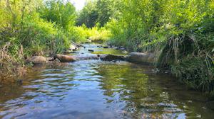
In Charlottesville, Virginia, a stream was struggling. Schenks Branch Tributary—which runs through the Botanical Garden of the Piedmont—had severe erosion, with banks as high as 12 feet in some places. The nutrients and sediment washing into the tributary damaged wildlife habitat and made the stream inaccessible to the public. Ultimately, that pollution flowed into the Chesapeake Bay, where it contributed to poor water quality and increased the risk of algal blooms.
The City received funding from the Virginia Department of Environmental Quality’s Stormwater Local Assistance Fund to restore part of the stream. But the waterway was tucked away in a wooded area where few people could see it.
“Many residents don’t interact with the stream on a regular basis. We needed a way to let the community see that the stream’s conditions are an issue, and we're working to address it.”
~ Ryan O'Banion, GISP, Senior Associate, Hazen
The Project
In partnership with the Botanical Garden of the Piedmont, the City hired Hazen and Sawyer to:
- Evaluate the health of the stream
- Design a restoration project that would make it healthy and accessible
- And educate the community about the project through a custom ArcGIS StoryMap
Hazen’s team worked with the City and the Botanical Garden to assess the stream, wading into the creek with a 360-degree camera, surveying, gathering environmental data, and doing extensive analyses. The team then developed a detailed restoration plan.
The Result
Finally, the team turned all the imagery and information they’d gathered into an immersive, information-packed narrative using an ArcGIS StoryMap. The story includes:
- 360-degree photos that give viewers an immersive tour of the stream, letting them see eroding stream banks, downed trees, and overgrown foliage up close
- Aerial drone video of the stream’s location
- An interactive map highlighting key restoration activities taking place in different spots, with photos and explanations of how each will help the stream
- Information about native plants the City is planting and how they fit into the Botanical Garden’s goals
- Examples of other streams transformed by similar work
- Key timelines, public meeting footage and contact information of project leaders
The result offered a quick, compelling way for people to get to know a water system in their own city, along with the people working to make it better. And it was all achieved using commercially available software from Esri combined with Hazen’s extensive stream restoration experience.
View the StoryMap below or online.
This stream restoration project was finished in June 2024 and completed its one-year warranty—an exciting milestone for all of the project stakeholders and the community.