How Georgia and Alabama Ended a Decades-Long Water War
Resolving a conflict over water in the Apalachicola-Chattahoochee-Flint Basin required a lot of collaboration. Hazen’s hydrologic models helped foster the dialogue.
In December 2023, news headlines across the South announced a breakthrough in a long-simmering legal battle over water resources: “Georgia, Alabama bury the hatchet in Chattahoochee River water case”; “Southern Governors ‘Proud’ to End Decades-Old ‘Water Wars’ Legal Dispute.”
Smiling photos of Alabama’s Governor Kay Ivey and Georgia Governor Brian Kemp were published alongside the press release. Both governors called it “a win-win solution.”
This agreement, or “treaty,” to follow the language of water wars, centered on how the U.S. Army Corps of Engineers (USACE) manages the Apalachicola, Chattahoochee, and Flint Rivers. The Corps is responsible for maintaining a delicate balance among dozens of competing water demands in the Apalachicola-Chattahoochee-Flint (ACF) Basin, and finally, after 30 years of litigation, Alabama and Georgia agreed on a plan for sharing the waters that form half of their border.
Listen as you go
Related Solutions:
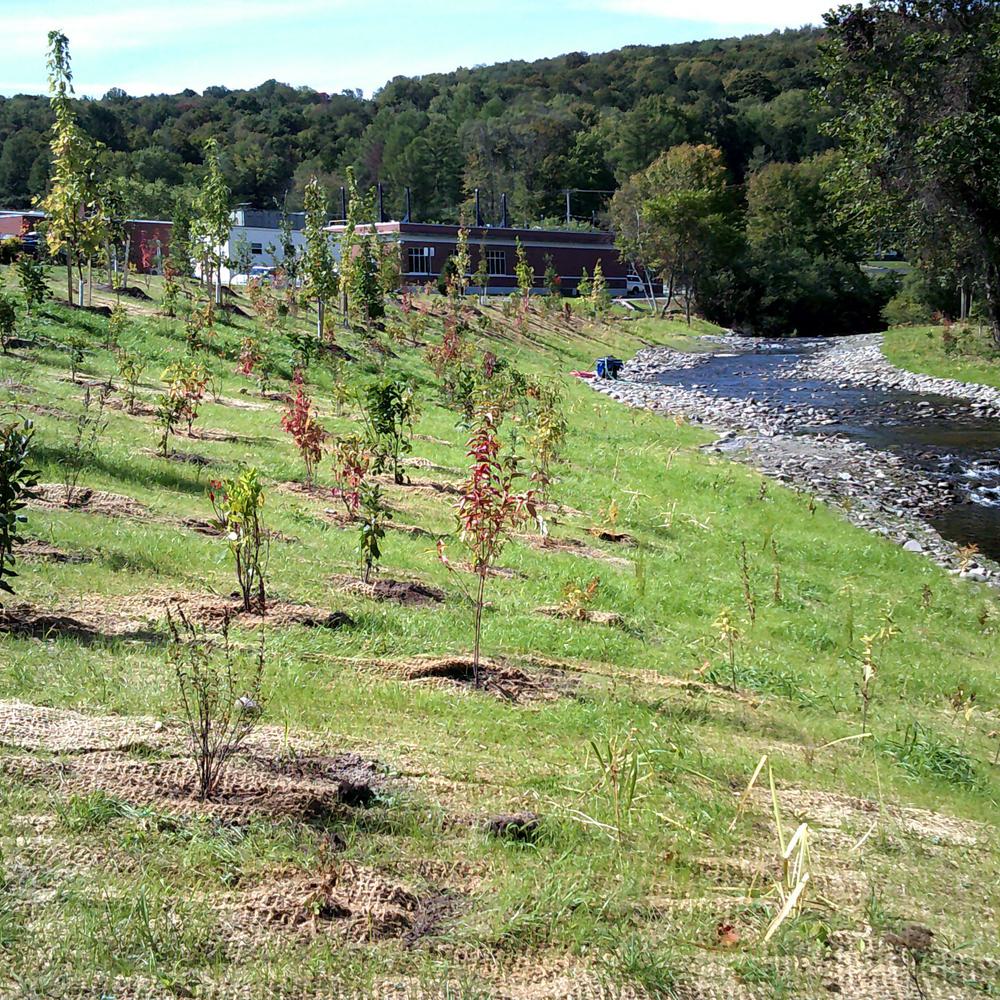
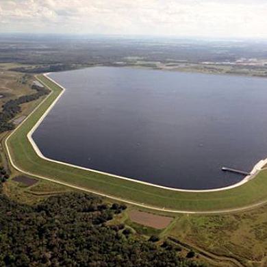
(Top image) Lake Lanier, a behemoth reservoir 50 miles northeast of Atlanta, stores 60% of the Apalachicola-Chattahoochee-Flint (ACF) Basin’s water reserves, making it the basin’s “main storage bucket.”

“This proposal is a big deal for Alabama as the Corps has never before set minimum water-flow objectives in the parts of the Chattahoochee that affect us,” said Governor Ivey in a statement. This settlement guaranteed dams in Georgia would release enough water to satisfy the state of Alabama.
Outside of the Southeast U.S., readers of these headlines might be surprised to learn that Alabama and Georgia, two verdant states rich with creeks and rivers, have long been embroiled in legal battles over these shared resources. But water wars are not just something that happens in arid regions.
Anywhere there are competing interests and rivers that flow across borders, there’s a need for proactive and collaborative management, and computer models are the tool that makes such collaboration possible. Hazen’s OASIS proved pivotal in the agreement.

The Chattahoochee River (above) flows about 430 miles through Georgia and Alabama before merging with the Flint River to form the Apalachicola River, which empties into Florida’s Apalachicola Bay.
Water Under the Bridge
At the heart of this conflict is the Chattahoochee River, which defines much of the border between Alabama and Georgia. Named by the Muscogee (Creek) people for the “painted rocks” near the Fall Line, the Chattahoochee enriches the fertile plains of both southeast Alabama and southwest Georgia.
The state of Alabama first sued the Corps in 1990 to prevent it from allowing utilities upstream in Metro Atlanta to increase their water supply withdrawals.
Upstream, the river provides 68% of the water supply for the Metro Atlanta region, home to 5.3 million people and counting. Downstream, farms, families, recreational users, and a nuclear power plant rely on freshwater flows from the river. For decades, water sharing has required a delicate balance, not simply between states, but across urban and rural communities throughout the ACF basin.


The Chattahoochee River provides almost 70% of the water supply for Metro Atlanta (above left) but also supports numerous downstream users like farms (above right, a Georgia cotton farm) and a nuclear power plant.
In 2023, through mediation, the two states finally settled on a proposal for water sharing. It took another year for the Corps to formally adopt this landmark agreement. Atlanta mayor Andre Dickens joined the chorus lauding the milestone as “a great day for the State of Georgia and everyone invested in the Apalachicola-Chattahoochee-Flint River Basin.”
These headlines were the culmination of many years of behind-the-scenes planning and negotiation. Governors and mayors celebrated, but was this just another skirmish in a seemingly endless war or a decisive victory?
Goats, Coyotes, and Donkeys
On a sweltering June morning, Danny Johnson, the managing director of natural resources for the Atlanta Regional Commission (ARC), points out a few goats grazing at the top of Buford Dam. The dam’s artificial hillside is too steep for lawnmowers, so the USACE keeps a herd of goats in a fenced area to manage summer's unruly grasses, berries, and briars—and protect the dam’s hydropower structures from birds that nest in those plants.

The gates of Buford Dam at the base of Lake Lanier. The U.S. Army Corps of Engineers releases a minimum of about 388 million gallons per day (sometimes much more) from the dam into the Chattahoochee River.
“They used to have donkeys to protect the goats from coyotes,” he explains.
Buford Dam is the control structure for most of Metro Atlanta’s water supply. Since the 1950s, operators have found creative ways—sometimes in the form of hoofed mammals—to fine-tune its operation.
Johnson’s job also requires a lot of creative balancing. He convenes and coordinates water utilities across the 15-county Metropolitan North Georgia Water Planning District. No one could be happier about the end of 30 years of water wars with Alabama.

Danny Johnson, managing director of natural resources for the Atlanta Regional Commission (above, by the Chattahoochee River), convenes and coordinates water utilities across the 15-county Metropolitan North Georgia Water Planning District.
Standing at the shaded base of the dam, where the Chattahoochee resumes its natural course south, Johnson explains the difficulty of keeping historical rainfall trends in mind when he talks about water supply challenges. “We are fortunate to have plentiful rainfall to keep our lakes and rivers full,” he says. “But there are always droughts around the corner.”
On top of the powerhouse, a digital display reads 1,071, as in, feet above sea level. Lake Sidney Lanier is at full pool, and the threat of running dry seems distant.
“I see things in maps,” Johnson jokes. “We’re all the way up at the top of the river system.” Metro Atlanta is perched on the subcontinental divide, the highest elevation of any major city east of the Mississippi. The region sits atop the headwaters of six major river basins.
“We have to do what we can to protect that small amount of water we have,” he added. “We have to take into account all the water needs up and down the river.”
That includes the Georgia water suppliers that draw water from the Chattahoochee River and other rivers like the Etowah River, including Fulton, DeKalb, Cobb, Bartow, Forsyth, and Gwinnett counties, and the cities of Cartersville, Gainesville, and Atlanta. All are parties to the lawsuit just resolved with Alabama.
Atlanta’s population makes it the eighth largest metropolitan area in the country, but it is also large geographically. Ever since its founding as a railroad hub, its position on a ridge in the headwaters of multiple river basins has made water supply a challenge.
To further complicate matters, granite bedrock underlies the region, so it’s not possible to serve this population with groundwater wells. And while Atlanta gets an average of 50 inches of rainfall each year to contribute to surface water supply, that rainfall can be unpredictable and extreme, periodic deluges followed by a dry spell. In contrast, rainy Seattle receives only 36 inches of precipitation each year on average, but it falls as a steady drizzle over days.
Atlanta’s leaders started planning for a major reservoir in North Georgia back in the 1940s. When the Buford Dam was completed in 1956, a dozen federal, state, and local dignitaries flipped a switch, closing the sluice gates and capturing the waters of the Chattahoochee River. A motorcade led to downtown Buford, where a granite core drilled to create the dam’s foundation was installed in a plaza to mark the achievement. “For the benefit of all mankind,” states a plaque on the memorial, and “for the purposes of flood control, navigation, power, recreation, and water supply.”
Demonstrating the region’s water challenges right off the bat, it took a full year longer than anticipated for the lake to fill. Today, this 70-year-old dam is responsible for the development of the Southeast’s economic engine, Metro Atlanta.
Between 2007 and 2008, Lake Lanier dropped by 20 feet after the driest spring on record. The red clay shoreline revealed not just lost anchors and lawn chairs, but whole sunken boats, dumped cars, and the remnants of roads and structures flooded beneath the reservoir. Lakeside community groups made the best of the situation by hosting lakebed cleanups, but the scene still felt apocalyptic.

One granite core that was drilled to create the foundation of Buford Dam, which was finished in 1956.

Droughts sometimes cause Lake Lanier to dip, exposing red clay shorelines and parts of the lakebed (above).
While the Chattahoochee flows through three more reservoirs managed by the Army Corps of Engineers, Lake Lanier is the main “storage bucket,” says Johnson. “Lanier is the workhorse that holds 60% of the total storage of the whole system.”
During times of drought, everyone wants reassurance that their part of the river will keep flowing. From Georgia Power and jet-skiers at Lake Lanier to trout fishermen and drinking water suppliers in Atlanta, from whitewater kayaking outfitters in Columbus, Georgia, to the renowned oyster fisheries of Apalachicola Bay, they all keep an eye on the weather forecast and the Corps’ dam release schedule. Florida and Alabama have sued for the reassurance of guaranteed flows during drought.
“The most important part of the river system is where the Chattahoochee and Flint come together and form the Apalachicola,” says Johnson. This is where Alabama, Georgia, and Florida, and all their combined water demands, come together. According to the manual that the Corps uses to manage flows, the flow rate at the state line must be maintained at 5,000 cubic feet per second (cfs). During a severe drought, that can drop down to 4,500 cfs.
This is what Johnson sees as the fundamental challenge: making sure water is shared equitably along the 486 river miles from the Buford Dam to Apalachicola Bay.

“How do you divvy up all this water?
Whose is it to begin with?”

Zooming Out
These are the questions before Megan Rivera and Eliot Meyer, seasoned experts in integrated planning and the operations of water resources systems at Hazen. Since 2006, Hazen has provided technical support for the Atlanta Regional Commission and their legal team at Jones Fortuna LP as they have sought to resolve litigation in the ACF basin.
Using Hazen’s own cutting-edge modeling software, OASIS, they developed a high-resolution model of the ACF river basin and surrounding river basins in Georgia. These models detail every individual facility withdrawing water or discharging wastewater and incorporate the forecasted needs of different water uses throughout the system.
But a model doesn’t just illustrate a snapshot of the river basin, it suggests opportunities for give and take. This includes scenario planning, demand forecasting, and climate risk analysis for future conditions in the basin.
Meyer, who has modeled basins similar to the ACF across the country, takes a zoomed-out perspective on Alabama and Georgia’s struggle.
“Individual partners are focused on their basin, their utilities, their clients,” he says. “But ARC has to look beyond city, county, and watershed limits to see the larger implications.” Models are a way to help stakeholders see a river basin holistically as a system rather than locking in on their individual components or local reference points.
It helps that a computer model of a river, at its most basic, resembles a subway system. Reservoirs are the big stations; stream gauges are mile markers. Stripped down to a conceptual diagram, our most precious resources appear finite and fragile.
When you see the system as a web of interdependent nodes, it’s clear that their fates are intertwined.

Along with many people, the water that flows from the Chattahoochee and Flint Rivers into the Apalachicola River and the Apalachicola Bay supports a biodiverse ecosystem, from oysters (top, in Apalachicola Bay), to ibises and alligators (lower left and right, in Lake Seminole).
Testing Scenarios and Options
Megan Rivera has spent the last 20 years studying the dynamics of the ACF basin, so the rivers and their users are deeply familiar to her. Having worked with ARC over a period which saw severe drought and flooding, she has deep knowledge of how the whole system responds to change and stress.
“Over the years, we’ve been given the opportunity to explore a lot of different ideas,” she says. “We tend to have a sense of what’s going to work and what’s not going to work.”
Rivera has cultivated direct communications with water utilities up and down the ACF basin. Her technical expertise is matched by the ability to listen to stakeholders and adjust based on what she hears. “When you live in model land, it’s very easy to experiment. You know the model can do it.” Meanwhile, stakeholders speak up about how certain changes would add complexity.
“One thing that’s been fun is learning from the Army Corps of Engineers, listening to what their instincts and experience tell them. What they can do, what is onerous for them to do," Rivera says.
The advantage Hazen brings to these negotiations is speed in testing scenarios and options. In the years since Alabama sued in 1990, the states traded many proposals and counter proposals. Hazen modeled these ideas within historic hydrology to determine if they make a difference or not in terms of flow rates.
“We try to ground-truth ideas in the best science that’s available,” Rivera said. “As people are thinking of new ideas and looking for compromises, we can run the numbers and give them answers quickly. And that allows the conversations to keep moving in a productive way.”
In litigation, parties need to be looking at the same data and models. In this case, that model was developed by the Army Corps of Engineers in their HEC-ResSim software.
When all the entities within a river basin can agree about the way a computer model of the basin is working, it forms a solid foundation for consensus. “You can start to come up with solutions that aren’t zero sum,” Rivera explains. “You come up with solutions that mitigate the downside for everyone in as much as possible.”
“Can we show that to ARC and say, there's room here to negotiate,” said Meyer. “And can we convince Alabama that yes, we’ll be able to meet critical water supply needs while also providing the flows they are requesting? We saw within the historic hydrology that these weren't going to be big impacts.”

The ACF Basin’s waters support everything from recreational fishing and whitewater kayaking to hydroelectric dams like Bartlett’s Ferry Dam (above, historical photo), which sits on the Georgia-Alabama border and is run by the Georgia Power Company.
Meyer would adjust the OASIS model, “because it was quick and we could put in these extreme conditions and make sure that we understood the implications.” Rivera and Meyer translated the most promising ideas into HEC-ResSim, allowing more direct collaboration with Georgia and Corps modelers.
“For ARC and this process, it mattered that we were always interested in making sure the model was correct but also as honest as it could be.”

Many different stakeholders in the ACF Basin keep an eye on the Army Corps’ dam release schedule, from Georgia Power and jet skiers at Lake Lanier to trout fishers in the Chattahoochee River (like the one above) to drinking water supliers, kayaking outfitters, and oyster fishers farther downstream.
Finding Flexibility
Lewis Jones, a founding partner at Jones Fortuna LP and expert in water, environmental, and natural resources law, has seen the difference the OASIS model can make when confronted with an impasse in negotiations. Jones and his partner John Fortuna have represented Georgia’s water supply providers in and out of litigation over many years.
Part of the process has been understanding all parties’ tolerance and sticking points. “People were fine with the general things, but it’s the exceptions that get you,” Jones said.
The OASIS model showed that both parties' needs could be met, even in times of drought. Jones relied on Rivera’s understanding of the basin to move the negotiations forward.
“We could prove to Alabama, internally and externally, that this operating scenario was realistic, that this was beneficial, that it meets the needs of all parties,” said Jones. “And you can't do that without modeling it and taking the time to test different analyses.”
Danny Johnson feels that this is where the OASIS model offers the most value.
“The purpose of the models is to stress-test the system and make sure that even in times of extreme weather, those decisions can't break the system.”
Finding compromises requires flexibility, and flexibility requires confidence. Jones explains that the cautious mindset of decision-makers is based on fear of worst-case scenarios.


The ACF Basin covers about 385 square miles across Georgia, Alabama, and Florida, including 78 counties and numerous cities, such as Columbus, Georgia (left), and Apalachicola, Florida (right).
“People are like, I can’t because I don't know what’s going to happen. I don't have a good understanding of where I've got flexibility,” he said. These models help supply that confidence. “There’s still uncertainty because the world's changing, the climate’s changing. But we have a pretty good understanding, based on history, of where we do have flexibility. There’s no doubt of the confidence that comes from having that analysis.”
Jones added that Hazen’s modeling work was “essential to have faith in the direction” the negotiating parties took, because it was done by experts who have long been doing it in this basin and other parts of the country.
“Having the Hazen team available and able to answer questions about policy decisions or legal proposals helped validate the basis for those to be effective,” said Johnson. “It gives us confidence that what we’re doing is for the long-term benefit of the region.”
You can produce incredible models and tell stories with that data, but all this work isn’t going anywhere without trust and a willingness to collaborate at the very highest levels. Rivera praised the governors for even considering the mediated agreement.
“Both sides were willing to look at what the model was saying in terms of what could be provided and what resulted in risk. People were reasonable and willing to talk and willing to look at the science.”
Lowering the Temperature
Few watersheds align neatly with political boundaries, so interstate water disputes are unfortunately common. But they need not escalate to lawsuits and “water wars.”
Water utilities, environmental groups, and industrial clients across the United States rely on OASIS for hydrologic modeling and resource planning. In fact, OASIS has been used to inform water allocation in river basins affecting about 20 percent of the U.S. population.
“These are the most interesting projects, because you’re bringing people together or using computer models as a tool to help people make real-world decisions.” said Eliot Meyer. “Uncertainty can cause anxiety. And if you can reduce that anxiety, if you can lower the temperature using computer models and data, that’s really satisfying.”
As a technical partner, Hazen is tasked with modeling ideas that are important for evaluating the impacts of any change. But it’s more than that. In the case of the ACF, says Meyer, “We were able to triangulate between two proposals or counter proposals to come up with a kind of third way.” For Georgia and Alabama, the results were refreshing.
“If you can get people in the room together, or at least talking to each other, you can find solutions.”

A boardwalk to Apalachicola Bay, where the ACF Basin’s waters meet the sea.