Predicting Source Water Quality with NASA Satellite Remote Sensing Data
Last Modified Jun 10, 2024
Water utility managers face the difficult daily task of safeguarding the public health and complying with water quality regulations while minimizing costs and environmental impacts. This difficulty is heightened in Texas, where rapid population growth has increased demand, forcing utilities to investigate alternative supply sources, including additional surface water sources. As one example, recent efforts to reduce subsidence in the greater Houston metropolitan area have led to a systematic shift from groundwater to surface water supplies.
Related Solutions:
As surface waters form an increasingly large portion of the supply portfolio, utilities are increasingly dependent on the quality of these waters. Variable quality and higher levels of organic matter make their treatment more difficult than that of many groundwater sources. To combat continued water quality degradation from human activities, increasingly strict regulatory standards for water quality and emerging micro-pollutants, utility managers with surface supplies could benefit from additional tools at their disposal, particularly ones that look beyond the treatment plant intakes to the broader watershed.
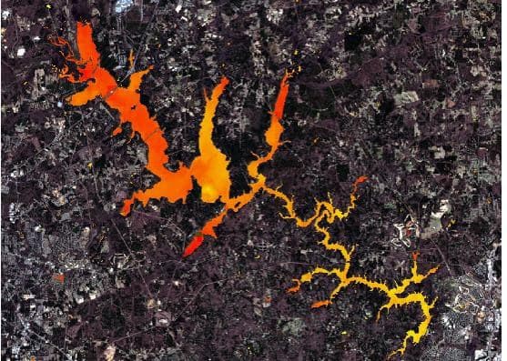
While it is well-established that terrestrial conditions within the watershed influence surface water quality, most water utilities do not currently have the resources to monitor watershed sources of contamination with great temporal or spatial detail. In most cases, a water utility’s knowledge of source water quality is limited to monthly or even quarterly measurements at a few discrete locations, typically within the water body itself. Satellite data, on the other hand, can provide frequent observations of the subtle changes to environmental conditions that drive water quality across an entire watershed. Further, the high temporal frequency of the satellite data captures watershed changes (e.g., development, seasonal vegetation coverage) as they happen, providing essentially real-time information on the current watershed conditions that will impact future water quality.
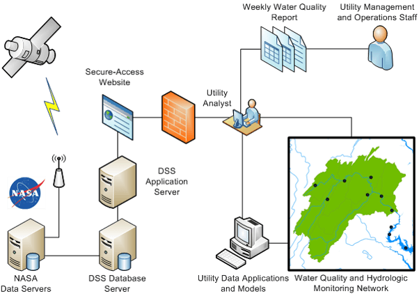
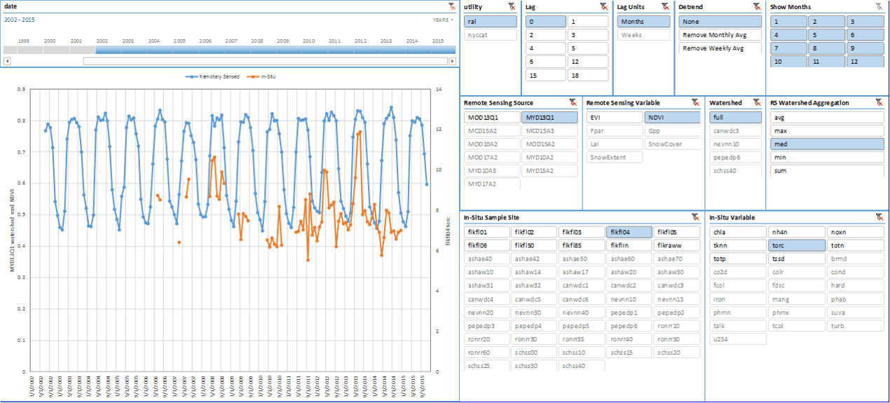
To promote the use of satellite remote sensing data towards advancing the water quality outlooks of water managers, NASA is funding a collaborative effort between Hazen and Sawyer, Riverside Technology, Inc. and the University of Maryland, Baltimore County to develop a web-based Remote Sensing-Water Quality Decision Support System (DSS). The tool will give water utilities user-friendly access to NASA’s satellite remote sensing data, filtered for the watershed of interest, and presented for utility staff to analyze and summarize for use by decision-makers. The DSS will also provide users with statistical analysis tools to help them identify correlations among remote sensing data sets and the utilities’ own in situ monitoring data. For statistically significant correlations, the DSS will present the user with a proposed model for predicting in situ water quality from remote sensing observations. It is hoped that the DSS will help forecast water quality conditions to inform treatment operational decision-making while also providing managers with information regarding the best uses of in situ monitoring resources.
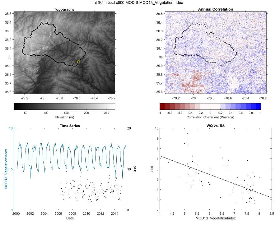
The project team is working with three utilities serving as case studies: the City of Raleigh, NC; Northern Colorado Water Conservancy District; and the New York City Department of Environmental Protection. Preliminary efforts have found that remote sensing data can potentially be used to predict disinfection byproduct formation potential and phosphorus concentrations in some waterbodies. Given Texas’ relatively high temperatures and the relative abundance of nutrients in Texas waterbodies, many of the state’s drinking water supplies are eutrophic to hypereutrophic. The ability to better predict the high seasonal variability in the quality of these supplies is expected to be beneficial to many Texas water utilities. Further, high-frequency satellite observations will be able to capture changing conditions in
Texas’ rapidly developing watersheds, enabling utilities to better understand resulting impacts on water quality. As more utilities adopt the DSS, the relationships between the remote sensing data and water quality will be better understood, potentially yielding further refinement of the predictive models. Development of the DSS could be improved with additional utility input and the potential inclusion of one or more additional case study utilities, and we therefore solicit input from Texas water utilities regarding their monitoring programs and surface water quality concerns. By synthesizing data from water utilities with NASA remote sensing data, we seek to develop a DSS that will directly improve utilities’ understanding of watershed impacts on source water quality, leading to better long-term planning and improved operational decision-making. This paper will present the development of the DSS, case study results, and potential application for Texas utilities.


