River Basin Water Supply Modeling
The predecessors to today’s sophisticated river basin models originated in the 1940s with scaled down physical models of river systems like the Mississippi. Water could be added in large volumes “upstream” to gauge where flooding might occur and infrastructure could be added to simulate the impact of a new dam or reservoir on those same flood conditions.
These models were developed with an understanding that local management of river processes was imperfect – that a bigger picture, holistic view was needed for effective management.
Over time, these physical systems were represented with electrical analogs, then with resistors and capacitors, equations, and ultimately with computer software. As computer power increased over time, the level of detail and sophistication of models advanced.
Basin water supply models are designed to simulate how storage and flow in networks of reservoirs and streams vary over time—from days to decades—using observed or proposed withdrawals by water users, return flows by dischargers, reservoir operations and evaporation losses, inter-basin transfers, and any other human or natural process that impacts the basin water balance.
How Models Are Created
Basin water supply models are designed to simulate how storage and flow in networks of reservoirs and streams vary over time—from days to decades—using observed or proposed withdrawals by water users, return flows by dischargers, reservoir operations and evaporation losses, inter-basin transfers, and any other human or natural process that impacts the basin water balance.

These models are used to evaluate the system-wide impacts of local water decisions and use on availability, water quality, and other criteria basin-wide. They are often used to support basin-wide regulatory planning and permitting, resolve disputes among water users, inform environmental impact assessments, detect supply risk due to drought, and evaluate future operational and structural options for improving supply reliability. Models may also include integration with real-time data systems for operational decision-support, inflows under climate change scenarios or paleoclimate conditions, and/or water quality models. Basin water supply models are typically developed through several common tasks, illustrated in the slideshow above.
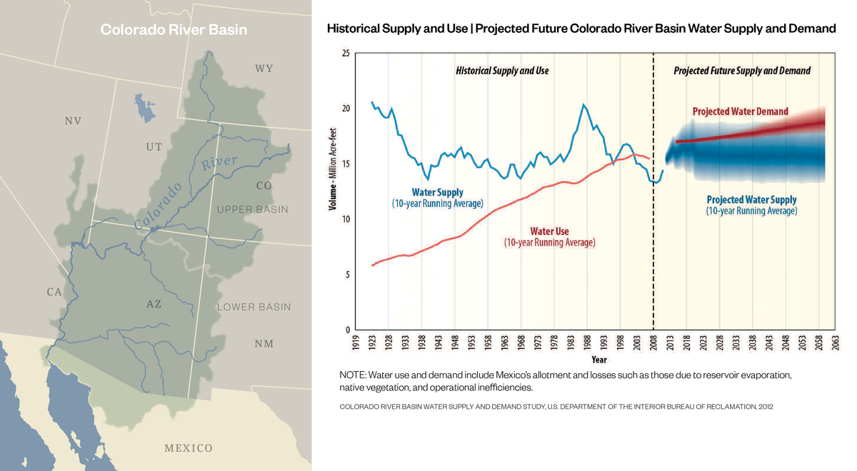
The Colorado River Simulation System (CRSS) basin model was developed in the 1970s by the Bureau of Reclamation and translated to the RiverWare software platform in the 1990s. The model uses inflow and demand data along with usage rules to route water through the system and is intended to be used for long-term planning, short-term operational planning, and regional or local planning. Long-term projections were used most recently in the Colorado River Basin Study (2012) that examined potential alternatives to mitigate projected future gaps in supply and demand through 2060.
CASE STUDY: Colorado River Basin Modeling Supports Local Planning Efforts
The Colorado River Basin spans seven states and encompasses 252,000 square miles. It serves more than 40 million people as well as over 5 million acres of farmland and is an important economic and water resource locally and nationally. Inflow varies greatly, and as demands have increased and drought persists, the need to prepare for the range of potential future conditions is paramount.
The Colorado River Simulation System (CRSS) basin model was developed in the 1970s by the Bureau of Reclamation and translated to the RiverWare software platform in the 1990s. The model uses inflow and demand data along with usage rules to route water through the system and is intended to be used for long-term planning, short-term operational planning, and regional or local planning. Long-term projections were used most recently in the Colorado River Basin Study (2012) that examined potential alternatives to mitigate projected future gaps in supply and demand through 2060.
The output of CRSS provides insight into potential future conditions and the model is under continuous development with new features added to better represent the system and provide improved tools for decision making. It was most recently used by Hazen to inform efforts to develop the City of Santa Fe’s Water Resources Planning Model.
The CRSS has been the primary tool for evaluating water supply, operations, and environmental impacts. It was instrumental in developing guidelines and evaluating treaty minutes. Likewise, the model will continue to be important in evaluation of options as the interim guidelines for operations expire.
CASE STUDY: Tennessee Duck River Basin Modeling Facilitates Consensus on Minimum Flows
River Basin models can play a key role in building relationships and solving problems with diverse and, at times, opposing stakeholder groups. When a model is developed collaboratively and/or transparently— fostering confidence in its outputs—negotiations, planning, and emergency responses can be grounded in the realistic conditions captured in the model.
Using Hazen’s OASIS modeling software a planning effort was conducted on Duck River and Normandy Reservoir with a 100-year daily historical inflow record. Analysis showed that the system would be able to meet projected system demand and downstream flow targets for the next 50 years with very high reliability. The Duck River Agency established a planning process to periodically review demand projections and other system requirements and in 2003, the Agency adopted its first basin water supply plan.
When a drought-of-record hit in 2007, both the model and relationships were already in place to negotiate acceptable flow and water use reductions. Trust in the model and between the various stakeholders helped to facilitate consensus on a drought response plan by the end of September and an environmental assessment by mid-October of that year. Operational changes were then adopted and continued through February 2008.
Hazen is currently using the basin model to evaluate allocation schemes that include a new withdrawal several river miles downstream from the existing utility intakes. Application of the OASIS model has provided a platform upon which regulators, utilities, and environmental stakeholders can reach consensus on key decisions in the Duck River basin.
Our OASIS modeling software is is an extremely powerful tool for utility operators.
CASE STUDY: Georgia Basin Modeling Facilitates Integrated Planning and Permitting Decisions
State regulatory agencies often rely on river basin models for planning and permitting activities. Georgia Environmental Protection Division (GAEPD) has recently joined Kansas, North Carolina, and Tennessee in acquiring a state-wide license for Hazen’s OASIS software to support the state’s water withdrawal permitting activities and Statewide Water Plan development.
Assessing potential local and basin-wide impacts of new permits anywhere in the state necessitates an unusual combination of fine spatial resolution and large geographic scope.
Through a pilot study for GAEPD, Hazen completed one such model for the Oconee, Ocmulgee, and Altamaha (OOA) River system which spans from eastern Atlanta and Athens to the coast near Brunswick. The OOA model includes each individual permitted withdrawal, outfall, and water supply reservoir on each reach and tributary, resulting in approximately 850 individual nodes (compared to 11 planning nodes in the prior model for Statewide Water Plans in the same basin). To build a model of this complexity, Hazen devised several enhancements to automate modeling procedures that are normally performed manually, including schematic development, upstream-downstream location searching, and unimpaired inflow calculation incorporating microscale basin-wide rainfall/runoff models.
The more granular model also benefits Statewide Water Plan updates, which have to contend with a range of stakeholders and could not previously take into account mitigation actions and corresponding impacts by individual users. With a runtime of only 5 minutes, the model can be applied in real-time during planning meetings. Through this and upcoming follow-up efforts, Hazen will develop similar models for all 15 major basins spanning the entire state. These models will be used to facilitate effective statewide planning to ensure that utilities, local governments, and regulatory agencies fully understand the implications of current and future surface water withdrawals, impoundments, and discharges on supply reliability. This effort indicates that value can be achieved efficiently in a package that can also be applied for future, collaborative decision making.