The Staten Island Bluebelt: 20 Years Later
A Triple Bottom Line Perspective of the Program's Long-term Performance
Staten Island became the fifth borough of New York City in 1898, but the majority of the island was fairly rural, featuring small communities and large tracts of open space. But following World War II, and the construction of the Verrazano-Narrows Bridge in 1964, rapid suburban development took place on the Island. The sudden growth outpaced the City’s ability to lay sewer lines, so developers installed residential septic systems and made nominal improvements for storm drainage.
Plans were developed in the 1960s with a traditional storm sewer system built under the roadways. However, this was dependent on building out the city map, which included crisscrossing the open spaces with roads and filling in existing streams and freshwater wetlands, particularly in the portion of the Island referred to as South Richmond. In the 1970s, New York State Department of Environmental Conservation was given authority to regulate freshwater wetlands, as was United States Army Corps of Engineers, which put tight restrictions on construction in the wetlands.
By the late 1980s, South Richmond was suffering from regular flooding as well as poor water quality in the streams due to failing septic systems, and it was clear that some type of sewer system would need to be built. However, building the sewer system per the plans would have destroyed the freshwater wetlands both through construction within the wetlands as well as diversion of stormwater away from the wetlands, which would drain them permanently. And building just the sanitary sewers would only address a portion of the problem and be a stopgap measure. New York City Department of Environmental Protection (DEP), the agency responsible for the City’s water and sewer system, faced the challenge of how to build a stormwater drainage network for South Richmond while preserving the wetlands.
Hazen and Sawyer, as subconsultant to DEP, starting working on the problem, in part in response to evaluations of water quality issues in the waters surrounding Staten Island. Together, we developed an innovative solution to incorporate the wetlands into the stormwater drainage network. Rather than divert runoff through underground pipes, DEP proposed that the wetlands and waterways would be called on to perform their natural functions – conveying, storing, and filtering stormwater. This concept at the time was novel – in the 1990s, the discussion of low impact developed had barely begun, and was just starting to be considered in the site development world, but not at a regional scale. Starting in the early 1990s, DEP started purchasing land within the wetlands. Even with the costs of the purchases, they would still be less expensive than building the large trunk sewers that would be required to replace streams. They also started the planning process of the drainage network, planning for storm sewers in the streets, directing stormwater to Best Management Practices (BMPs) in the open spaces and existing wetlands within the watershed. Sanitary piping would also be in the streets, and diverted around the open spaces to preserve the open spaces and wetlands as much as possible.
By 1997, the Environmental Impact Statement (EIS) for the first watershed, Richmond Creek, was completed, with a plan for eight BMPs, 20,000 linear feet of storm sewers and 56,000 linear feet of sanitary sewers, and the first BMPs were constructed. Planning and environmental reviews took place concurrently with design, eventually covering 19 watersheds and over 17,000 acres of land.
Some of the factors that would lead to the success of the program were community acceptance and maintenance. Initially, the community was very skeptical about the plans for the drainage network, and were demanding a traditional sewer network. It became clear that without community support, it would be difficult to move forward with the project. Critical to the success was integrating the community into the program. This was achieved through holding community advisory council meetings bi-annually, being responsive to the concerns of the public, and incorporating their concerns into the program. After the early BMPs were successful in addressing the flooding problems, as well as providing a number of other co-benefits, the community was fully on board, and now the most common complaint is “when is their BMP going to be constructed”.
The Bluebelt program grew overtime to address major drainage issues in the Mid-Islands as well. In this area of Staten Island, the topography was particularly challenging, because of its flat topography, barely above sea level, and tidally influenced waterways with tide gates that prevent tidal backflow. Because of the tide gates blocking flows, storm events that occur during high tide often inundate many streets and structures in the watershed. Here, the BMPs were able to be integrated into existing freshwater wetlands and provide a vital role to detain stormwater during high tide, when the closed tide gates prevent outflow from the system.
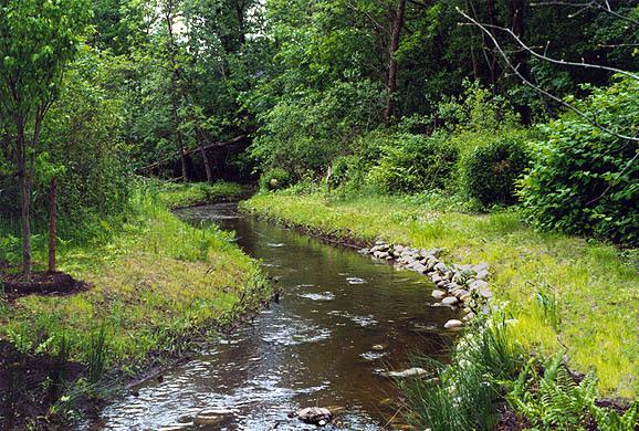
To date, 59 BMPs have been constructed, 17 are in construction and 48 BMPs are still awaiting construction. The first BMPs to be constructed have now been on line since 1999, and have been an overwhelming success. Areas that had been subject to flooding prior to the Bluebelt featured no street flooding following storms larger than the design level of service, including multiple hurricanes. Water quality has improved dramatically throughout the watersheds, and this has led to habitat successes such as the return of the American Eel to Richmond Creek.
Now, 20 years later, we are looking back at these BMPs and the Staten Island Bluebelt program and the performance has been stellar. DEP was concerned about maintenance, but they have found that the need for large scale maintenance has been far less frequently than originally expected, with landscaping being the most important piece. This has been a way to incorporate the community further, through Adopt a Bluebelt programs that allow community groups to perform routine maintenance. The BMPs also provided a host of co-benefits such as improved aesthetics, recreational value (paths around the BMPs), ecological benefits (improvements in quality of wetlands), preservation of open space, carbon sequestration, energy reduction and overall increase in property values surrounding the BMPs. Evaluating this from a triple-bottom-line perspective only enhances the cost effectiveness of this approach, and has made this a prime example of a program to repeat in areas with challenging stormwater issues throughout New York City and beyond.